
Shaftoe Crags – queen of the ridge
Shaftoe Crags with its sweeping panoramic views across one of England’s best-preserved rural landscapes takes you back to Northumberland’s ancient roots.
On a clear day you can see forever – well, as far as the Northumbrian coast and across to the dark silhouettes of the Simonside Hills.
This remote area has changed little since the Romans and there are still traces of the earlier ancient landscape, from Iron Age burial mounds to hilltop settlements.

Sweeping views from Shaftoe Crags
Two popular tourist attractions, Wallington and Belsay Halls, are near neighbours but a detour to Shaftoe Crags provides a rewarding walk for lovers of the great outdoors.
Start your walk near the main Bolam Lake visitor centre and take a detour to this landscape of small farms, craggy rocks and strange archaeological features.
Signs of the past

Green and pleasant agricultural landscape
This gentle farming landscape with its sheep and dairy cows is peaceful with lush, green meadows and clumps of woodland.
But the countryside around Shaftoe Crags throws up many surprises and unsolved mysteries.
Early in the walk you’ll discover a strange rounded tumulus or burial mound dating from Iron Age times or perhaps earlier.

Tumulus at Shaftoe Crag
The exact meaning of ‘The Poind’ is unclear with claims that it means ‘property or possession’ whilst others believe it could relate to a pinfold or ‘pound for animals’.
The main stone was one of two rough-hewn standing slabs which guarded the entrance to the mound, but only a single stone remains. The other stone was carted off to nearby Wallington Hall in the 1700s where it can be found today.

Standing stone at Shaftoe Crags walk
The burial mound was also important during Medieval times when high spots in the landscape were used as ‘watch points’ or early warning systems to avert Scottish border raids.
Historic records show that night watches took place here in the 1550s with two men patrolling the area in case of attacks from Scotland.
The Devil’s Causeway, a Roman road, runs to the west of the mound, a sign of the strategic importance of this area to the Roman Empire. Some archaeologists believe the name may have come from the Anglo-Saxons who often attributed large Roman structures to the work of giants or devils.
Craggy peaks

Shaftoe Crags viewpoint
Further along the walk you’ll arrive at the dramatic limestone edge of Salter’s Nick with its rocky outcrops and panoramic views of the countryside.
Next to this exposed rocky crag, there was once an Iron Age Fort although little is known about the people who lived here. The elevated site would have made this a great place to look out for approaching enemies.
The south end of the fort comprises a series of defensive walls and the foundations of round-houses. To its north you can see the remains of an Iron Age field system of Romano-British origin.

Heather and limestone rocks
Look in the fields for the Victorian Jubilee stone and an ancient rock with badly worn cup and ring marks. Sadly, I missed both features because I was too busy fighting my way through the bracken and heather below the crags.
Shaftoe Crags is a great place for a picnic but keep back from the edge because there’s a sheer drop to the bottom.
Looking down from Salter’s Nick at the track below, you can imagine the smugglers who used pack horses to transport illicit salt into Scotland during the time of the Salt Tax in the 18th Century.
Illegally distilled whiskey was one of the goods that was brought back on the return trip from Scotland.

Iron Age fields with Wallington Hall in the distance
From the top of Shaftoe Crags there are excellent views across the surrounding Northumbrian countryside. Take a pair of binoculars and grab a ringside seat to make the most of the sweeping panoramas.
But a word of warning. This rocky crag is very exposed and can be windy as I discovered to my cost. A trip to the hairdressers is now needed to detangle my mad mop of hair!
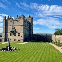
In the far distance you can see the country estate of Wallington Hall, the popular National Trust property which was home to the Trevelyan family in the 1800s.

Wallington Hall
Walk further along the Shaftoe Crags track and discover the so-called Devil’s Punchbowl, an impressive outcrop of rock with a gnarled appearance.
This rock-cut basin is named after an incident at a wedding in 1775 when guests filled it with several gallons of wine. The groom was William Blackett who lived at nearby Wallington Hall. What a weird wedding booze-up that must have been.
The landscape becomes wilder at this point with heather and heath taking over from the lush pastures of the farms and fields below.

Shaftoe Crags
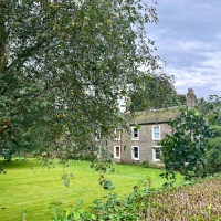
On the route back you’ll come across East Shaftoe Hall, a private house which is a grade 1 listed building.
Look out for the pele tower, a defensive building designed to repel border raiders. It’s a stark reminder that this was bandit country.
Boulders and climbers

Bouldering – popular with climbers
Shaftoe Crags is full of oddly shaped, sandstone boulders so it’s no surprise that it’s popular with the climbing fraternity.
My feeble attempts to copy the bouldering experts proved to be ill-advised as I stumbled at the first hurdle – I couldn’t even manage the low-level rock indentations and finger holes.
This athletic climbing activity requires a lot of skill, practice and controlled physical strength. None of these assets I possess, even in small measure!

Tammy’s unsuccessful bouldering efforts
Top of the world
A short detour off the path takes you back uphill to a viewpoint with a trig stone and yet more stunning panoramic vistas across border country.

Top of the walk
Once you’ve descended from this path, the landscape changes with pastures full of sheep, dairy cattle and horses dominating the area.
There’s a few surprises on the way back including a sheltered, stone walled garden and a dammed fishing pond with its own habitat.
As you walk through the open fields back to the car park, you’ll encounter a dairy herd with their calves but beware of the large bull that is roaming around!

From crags to countryside
This is a great, short walk that takes you back in time to Northumberland’s Iron Age and Roman history.
Archaeologists have found evidence of rock shelters used by early prehistoric hunter-gatherers who lived in this wild place. But there are plenty of hidden ancient mysteries still to be solved.
For today’s walkers this is the perfect place for a panoramic picnic and a stroll back in time.
Tammy’s Guide – Shaftoe Crags, Northumberland

Windswept Tammy at Shaftoe Crags
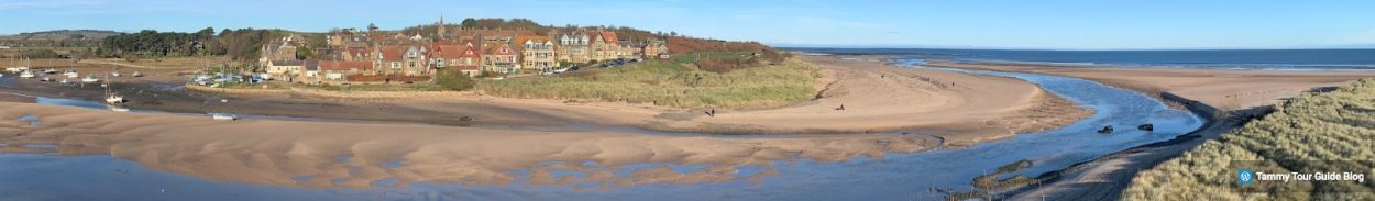
Shaftoe Crags is located in Northumberland near Belsay village, close to the hugely popular Bolam Lake Country Park.
Look out for a well-made farm road which leads to a small parking area. The turn-off is next to Bolam West Houses on the main road.

Shaftoe Crags – longer walk c/o Northumberland County Council
Start the walk from the car park and back-track on yourself to see The Poind and his Man tumulus before continuing beyond the car park through the fields to the rocky landscape of Shaftoe Crags.
The 3.8 mile circular route around Shaftoe Crags is easy to moderate with a few slopes and inclines – it is generally fairly flat.

Shaftoe Crags and the smugglers’ route
If you’re short of time there’s a 2 mile route around the crags which takes you to the main sights and viewpoints.
Alternatively, extend your walk by returning via How Burn and Shortflatt Tower. On the day we visited, Shortflatt Tower was hosting (Ant and) Dec’s wedding reception. Sadly, there was no invite for us!

Mysterious landscape
Why not combine a morning walk and picnic with an afternoon trip to Wallington Hall – read the blog feature
Categories: Archaeology, England, Heritage, Nature, Newcastle upon Tyne, Northumberland, Travel, Travel, UK, Walks