
Horses on the Frisian Islands
The West Frisian Islands are Holland’s wildest and most remote travel destination. They are what you might call ‘the back of beyond’.
You can’t get much further north than this archipelago of islands which form a chain off the tip of Holland in the Wadden Sea.
The islands are on UNESCO’s World Heritage Sites list which instantly attracted me to them. I love remote islands so this was an essential trip, even though it required careful planning.
Time and tide

Moving landscape – the West Frisian Islands
The history and landscape of the Frisian Islands (Waddeneilanden) has been shaped by the sea.
The West Frisian Islands are the remains of an ancient sandbank, a remnant of the last Ice Age. For centuries the sea has been eroding the islands’ sandy edges.
Several islands have been abandoned to the elements including Griend and Rottumeroog, a testament to the wild and unpredictable nature of this habitat.
It wasn’t until the 17th and 18th centuries that the landscapes became more stable with the building of dikes.
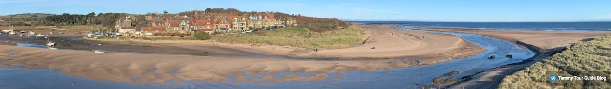
Our main destination was Schiermonnikoog, one of the largest of the islands, recently voted the prettiest place in Holland.
The island also boasts the broadest beach in Europe. Visions of beach combing, sea birds and sand castles filled our heads as we travelled north.
The Great Northern Edge
We drove from Amsterdam in a camper van, breaking our trip in Enkhuizen before driving to Holland’s north coast, a trip which took another couple of hours
We knew that getting onto the island would mean abandoning the van at Lauwersoog ferry port because no cars are allowed on Schiermonnikoog, other than those belonging to islanders.
Time to deploy the bicycles and outdoor gear.
After a surprisingly calm crossing in very windy weather, we arrived on the island after a short 40 minutes cruise. It looked as wild as we had hoped but the first thing that hit us was the wind!

Wild island
Rather like our own North East England coastline back home, this is a place that can be windy even on the brightest of days.
Cycling the short distance into the main village was a struggle because of the swirling cross-winds.
I looked like Nanook of the North, wrapped inside my furry jacket and hood, as I battled with the larger gusts which nearly knocked me off my bike.
So we cycled further inland along a more sheltered route which took us along fields of birds including large flocks of Barnacle Geese and Lapwings.
Finally, I was able to look at the pretty scenery and nature without worrying about falling off the bike.
Grey Monk Island
We took a trip around the main village with its picturesque, quaint cottages. It’s like walking back 200 years with little of the hustle and bustle of the outside world. Time seems to have stood still here.
Its sleepy, gabled cottages date back to the 1860s although many newer properties have been added in a similar style.
Schiermonnikoog’s roots date back to the 1400s when Cistercian monks lived in Klaarkamp Abbey. In fact, the island’s name can be translated as ‘Grey Monk Island’.
When the monastery was dissolved, the island became the property of the wealthy Stachouwer family. For three centuries the island remained private property.
In the 1700s it was divided into villages and the street layout became more like it is today.

Schiermonnikoog village
When the Stachouwer family sold the island, John Eric Banck, the new owner started planting the sand dunes with marram grass to stabilise them.
It’s easy to forget that the island is a changing, dynamic eco-system. Today you can walk or cycle along the dike which runs across the southern perimeter of the island.
But the largest village, Westerburen, had to be abandoned around 1725, when it became the victim of drifting sands and the encroaching sea.
The island has moved 15 miles east since the Middle Ages as a result of ocean currents, tides, winds and ‘shifting’ dunes’. We should have guessed it would be windy!
The island’s colourful history takes in the Napoleonic War and Second World War because of its strategic location.

Old style houses on the Frisian Islands
When the Germans invaded the Netherlands during World War Two, the Wehrmacht occupied the island and heavily fortified it as part of the Nazi’s Atlantic defences.
On 11 June 1945 the island became the last part of Europe to be liberated from German occupation. It’s hard to imagine what life must have been like here under the Nazis.
On the beach
After a tour of the town and its history, it was time to hit the beach for lunch – or at least that was the plan.
Soon it became obvious why there were so few people out and about. The beach was even windier than the harbour road.
My poor bike was getting blown around like a row of tottering nine pins in a bowling alley.

Wooded picnic spot
Undeterred we soldiered on, found some shelter on the inland bike paths which criss-cross the island – and even discovered the perfect picnic place.
To my great surprise, we managed to eat our sandwiches without getting too much sand in them.
We heard the sound of willow warblers in the low trees but even the birds had the good sense to have taken cover.

Life’s a beach
Back on the bikes we drove down to the main western beach, dismounted and walked the short distance over the dunes, only to be blasted by a ferocious wind tunnel.
Soldiering on, we admired the stark beauty and atmospheric landscape of this strange place but it was a struggle to walk against the wind.
There was nobody to be seen – perhaps we were the only people mad enough to venture out in the conditions.
As we enjoyed the solitude, we spotted a small horse-drawn carriage drawing towards us on the edge of the horizon.

Horse-drawn carriage on the horizon
As it grew nearer and moved slowly along the edge of the Westerduinen, it was like a scene from a movie.
When it arrived, the covered wagon dropped off a party of tourists who huddled on the windy beach for a few minutes before remounting and continuing on their way.
The horses were a special, hardy breed with thick coats to protect them from bad weather. They needed to be in this wind!

Horses on Schiermonnikoog
Windy and wild
The wind was getting a bit too much for us so we hopped back on the bikes and cycled inland where the wind was less gusty.
En route we popped into a bird hide at Westerplas overlooking a small lake but there wasn’t much action.

View from Westerplas bird hide
Even the normally rugged ducks, geese and waders had taken cover from the winds.
A flock of Barnacle Geese had sensibly flown onto a sheltered farmer’s field nearby, a scene reminiscent of rural Holland in an earlier century.
It was a scene reminiscent of an old Dutch landscape painting from the 18th Century.

Barnacle Geese on the fields
There were great views of these black and white striped geese from the Waddenzeedijk (Wadensee Dike) especially with binoculars.
Much of the island’s landscape is influenced by man’s intervention.
Even its salt marshes were turned into polders to create grassland and farmland and dikes were built to protect the land.

The dike – holding back the tides
Reflecting on the dynamics of this windy, ever-shifting landscape, I’d lost any sense of the time.
I was shocked to discover that we only had 20 minutes before we needed to get to the ferry for our return trip to the mainland.
We had to abandon plans to visit the Nordeduinen beaches with their impressive broad sands.
So it was back on the bikes and a ride through farming country, admiring the old farms strung along the flat Dutch landscape.

Bird paradise
One weird thing we discovered was that 100 people on the island speak a Frisian dialect called Skiermuntseagersk which isn’t dissimilar to Old English.
Looking at the words, there are bizarre similarities to Geordie, our local tongue back home.
For example, the Geordie word for child is bairn whilst the Frisian dialect version is bern. It seems that the Frisian people have an affinity with our own Northumberland culture!
I’d love to return and explore more of these islands on a future trip.
Schiermonnikoog is definitely a walk and cycle ride on the wild side. My teeth were still chattering when we got back to the port.
This island is a remarkable places. It’s great for nature and wildlife – but next time I hope it won’t be quite as wild and windy!
Tammy’s top tips – Frisian Islands
Getting there
Schiermonnikoog is located on the West Frisian Islands off Holland’s most northerly coast. We took the DFDS Ferry from the UK to Amsterdam and drove north to Friesland, a journey of 3.5 hours.

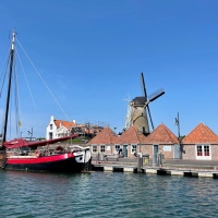
Schiermonnikoog village
The ferry to Schiermonnikoog runs from the village of Lauwersoog and the crossing takes 45 minutes. It’s a modern ferry with a cafe and facilities on board. No cars are allowed without a residents’ permit.
Tickets can be bought online or on the day at the ferry office. The ferries run two-three times each day in both directions during the spring, summer and early autumn.
Check ferry times before you plan your journey. The trip needs a full day. It’s possible to stay overnight in holiday homes and camp sites on the island.
Back on the mainland, there’s a small camper van site for overnight trips at Lauwersoog marina overlooking a pretty lake. There’s a larger motor home and camping site nearby called Lauwersoog Camping in the National Park.

Hire or take a bike
Before you go…
Don’t forget to buy a map of the island on the ferry. There is very little information in English but the map will give you the basics and enable you to get around.
The National Park website has the best information about the islands in English. Most local guide books are in Dutch.
Schiermonnikoog is only 9 miles across and 2.5 miles wide so it’s easy to get around It’s the perfect place to take bikes. The island has 20 miles of bike routes. Bike hire is available on the island.
Check out the Netherlands Tourism website for the bigger picture.

Restaurant in main village
Alternatively, there’s a bus from the ferry port to the village and the rest of the island, if you’re on foot.
The main village on Schiermonnikoog has a selection of shops, restaurants and cafes.
This is one of a number of the Frisian Islands that can be visited. Also look for trips to the islands of Ameland, Terschelling, Vlieland and Texel via Island Hopping ferries.
Schiermonnikoog is great for nature with its stunning array of flora including grasses, algae, mosses, flowers, plants and trees. Look out for guided walks across the fascinating tidal flats.
The island is a brilliant bird watching spot with spoonbills, egrets, avocets, terns, marsh harriers and lapwings. Its rich ecosystem boasts variety of habitats including wetlands, dunes, beaches, mud flats and bogs.
Look out for seals bobbing around in the waters around the islands.

Tammy goes wild


2 replies »